DECEMBER 2013 Many of you may have followed our postings on Facebook as we traveled down the Baja to Guerrero Negro and onto Muleje and Loreto. However, here is a photo journal of our trip.
Our daughter, Beth joined us for the trip as she had some end-of-the-year time off work.

We left on Sunday, December 22nd.
Our daughter, Beth joined us for the trip as she had some end-of-the-year time off work.

We left on Sunday, December 22nd.
DAY 1: Penasco to Ensenada.
I guess we just really didn't take so many photographs on this first day as we have all traveled this road several if not many times before...We decided to turn south at Tecate and drive thru the Guadalupe Valley - Baja's wine country. The vineyards were empty of leaves and dormant. But it is a beautiful drive regardless.
Little did we know then, that in just a few days our option of traveling to Ensenada by way of Rosarito would be nearly made impossible by a crazy event of nature.
Just 6 days later and this option is no longer an option.
http://www.bajainsider.com/

We arrived in Ensenada in the early evening as a Cruise ship was readying to depart.

We checked into our downtown hotel, wandered the streets and found a stop for dinner.

We checked into our downtown hotel, wandered the streets and found a stop for dinner.
Our drive today was about 350 miles.

DAY 2: Ensenada to Guerrero Negro.
We started our second Day slowly without a care in the world... Thinking we had just a slightly longer day today (only 20 or 30 miles more today...) However, after a long slow road outta town and then a tedious series of ridiculous, mind-numbing construction zones, and we suddenly realized we had averaged only 30 miles per hour for our first three hours of the day!
It was close to noon and we had barely moved down the map!
It was close to noon and we had barely moved down the map!
Finally, the road opened up and we hurried along the highway with views of the ocean off to the right.

Noticing on the map a Sea Lion Sanctuary we took off on a rugged dirt road towards the ocean. After driving quite a way, we were debating if we had turned wrongly, when we spotted a small fishing camp out on the beach. We continued down to it and there was a small parking lot and a weird overlook.
It was not until we stood on the overlook that we finally saw the sea lions basking in the sun inside of a open cave where the ocean water rushed in and out.

From our overlook they looked like giant slugs.
But with the zoom lens, we soon realized they had spotted us, too!

Returning to the highway (and now hours behind schedule!) we began a search for a lunch stop.
Russ knew of Mama Espinosa's and there it was on the road as we drove through El Rosario. It was an excellent lunch stop. We each tried a different menu item and we were all satisfied!
(Cheeseburger, Fish Tacos, Mexican Food and fresh Crab Soup) Delicious choices.

Departing El Rosario, we chased the fading sunlight and shadows down the road.
The scenery abruptly changed as we moved inland.

Desperately aware that we were some 220 miles from our destination and being practically the shortest day of the year, our daylight seemed to be fading fast.
And then we took note of one small detail on the map . . .OOPS!
There were no gas stations noted for miles and miles (. . . and miles!)
Entering the small and quiet town of Catavina, several enterprising guys were set up selling gasolina....
Surely, we don't really need to buy gas off of the side of the road.
But there were other cars lined up and we stopped.
After calculating and re-calculating, we decided to not risk running out of gas after dark in the desert of Baja. (Really? How surprising! I guess we just are not as adventurous as we could be...)
We bought 5 gallons for 350 pesos and Yes, we did consider it a bargain.

Just past this small town, we drove across what looked like a spring with water on the road
and an oasis of palm trees. Then, immediately it was back to the Desert!
and an oasis of palm trees. Then, immediately it was back to the Desert!

Into a vast cactus forest, we were soon nearing the Protected area of
the "cirios" or so said the map.
Being completely unfamiliar with this term, we did not realize these are a bizarre type of cactus or tree.
We would see thousands of these as we continued on thru our trip.
The desert seemed at times to be perfectly landscaped just for the tourist.
FACT: The cirios is the same as the boojum tree, a unique species that is an unusual plant
found native only in the deserts of Baja and Sonora, Mexico.
Really beautiful!
But oddly in a "Dr. Seuss' Garden" sorta way.

Long after dark, and with 375 miles on the odometer, we finally arrived at Guerrero Negro.
We checked into a hotel and searched for a taco stand.
Note to self: Day 2 needs better planning.
DAY 3: Guerrero Negro to Santa Rosalia.
 Guerrero Negro is NOT home to any luxury, up-scale hotel chains that we could find.
The place doesn't seem to be a place that invites the snow bird to hang out all winter.... It is more of a stop-over point for travelers or a place to sleep at night while you go in search of whales during the day.
However, we found a quiet hotel with a helpful host and a nearby 24 hour cafeteria (with hot coffee) and a taco stand. . . Pretty much the basics for Mexico.
Once we found there would be no whale watching this time (the season will not start here until January),
we anxiously hit the road.
Just to be sure they were telling us the truth, we drove out to the entrance of the Estero.
We were stopped by a guard for the salt mine. Apparently, this salt mine is massive, employing 750 full time workers. The salt deposits continue miles out to the ocean bay. Creating an almost non-ending supply of salt. This is thought to possibly have something to do with why the whales arrive here to have their babies.
 Here are some photos of the massive salt crystals that are laying around.
And salt seems to be "growing" on everything!

Ok enough of the white stuff... Onto San Ignacio.
Some 90 miles inland is the historic town of San Ignacio.

"San Ignacio, with more date palms than residents, is a true oasis that sits in
sharp contrast to the desert scrub, prickly cactus and volcanic rock of the
Baja desert that completely surround the town." (www.allaboutbaja.com)

"San Ignacio is a slow moving, relaxing little town that will infect your soul with laziness. San Ignacio has been a favorite for travelers since the mission days, surrounded by mesas, the oasis, being a respite for many a Baja traveler." (www.bajainsider.com)
 In the quiet town square is the old Misión San Ignacio Loyola.

The place doesn't seem to be a place that invites the snow bird to hang out all winter.... It is more of a stop-over point for travelers or a place to sleep at night while you go in search of whales during the day.
However, we found a quiet hotel with a helpful host and a nearby 24 hour cafeteria (with hot coffee) and a taco stand. . . Pretty much the basics for Mexico.
Once we found there would be no whale watching this time (the season will not start here until January),
we anxiously hit the road.
Just to be sure they were telling us the truth, we drove out to the entrance of the Estero.
We were stopped by a guard for the salt mine. Apparently, this salt mine is massive, employing 750 full time workers. The salt deposits continue miles out to the ocean bay. Creating an almost non-ending supply of salt. This is thought to possibly have something to do with why the whales arrive here to have their babies.

And salt seems to be "growing" on everything!

 | |||
Some 90 miles inland is the historic town of San Ignacio.

"San Ignacio, with more date palms than residents, is a true oasis that sits in
sharp contrast to the desert scrub, prickly cactus and volcanic rock of the
Baja desert that completely surround the town." (www.allaboutbaja.com)

"San Ignacio is a slow moving, relaxing little town that will infect your soul with laziness. San Ignacio has been a favorite for travelers since the mission days, surrounded by mesas, the oasis, being a respite for many a Baja traveler." (www.bajainsider.com)

Built in 1786 of four-foot thick volcanic rock walls.
To its left is the local indian petroglyph museum display.
After a late afternoon lunch on the relaxing porch of the Beans & Rice Restaurant
we off to our final destination of the day: Santa Rosalia.
 Another hour's drive and we have completely crossed the Baja from the Pacific side
this morning to the Sea of Cortez tonight.
 The old El Morro hotel sits above the town and has spectacular views.
The hotel was built in the late 1800s
and has that somewhat romantic "lost in time" feel to it.

DAY 4: Santa Rosalia to Loreto
This is an extension to our fact-finding trip which ends in Santa Rosalia.
Now we are off on our side trip.
Visions of Mulege and Loreto have been with us for years.
And today we are off to explore.
 Mulege is called an "Oasis town". It sits at the mouth of the Santa Rosalia River.
 Peaceful and tranquil.
But there are plenty of obvious signs of the intense flooding they've experienced in the past few years.
Just south of Mulege, is a row of beaches that lay along "Conception Bay".
They are BREATHTAKINGLY FANTASTIC!
Let the photos tell the story!


. . .and finally Loreto.
Our farthest south point for this trip!
 Tonight we relax.... Tomorrow we explore!

DAY 5: Loreto

 First Mission on the Baja. Established 1697.
The sign says it is “Head and Mother of the Missions
in Baja and Alta California”.


Later in the day, we decided to return early to Santa Rosalia and determine the ferry situation...


Basically, no trip today.... because of the weather
(a seemingly beautiful, sunny day - yet, apparently windy out in the Sea.)
And, ."Muy probable" there will be a trip in a couple of days...
Not so very reassuring.
As a option we had been told that the road to San Felipe was mostly paved now.
Only a 35 mile stretch was very, very slow going.
A restaurant waiter in Mulege said that all you had to do was be patient
and in 35 miles you would be "rewarded".
He said it cut 5 hours off of the Mulege to Mexicali trip.
Interesting information to sleep on.
We returned to Guerrero Negro that evening.
We chose a different hotel on this return trip; but were not any more impressed.
DAY 6: Guerrero Negro to San Felipe
The next morning we left Guerrero and when the NEED for breakfast overtook us, we found a
roadside cafe called Mauricio's and stopped. It was a crazy busy little place, where it seemed travelers had called ahead - and briefly stopped to grab take-out orders and then continued on their journey.
The sign out front said we were again entering the Protected area for the Cirios.
This time, we had to stop up the road and get a closer look.


we off to our final destination of the day: Santa Rosalia.

this morning to the Sea of Cortez tonight.

The hotel was built in the late 1800s
and has that somewhat romantic "lost in time" feel to it.

DAY 4: Santa Rosalia to Loreto
This is an extension to our fact-finding trip which ends in Santa Rosalia.
Now we are off on our side trip.
Visions of Mulege and Loreto have been with us for years.
And today we are off to explore.


But there are plenty of obvious signs of the intense flooding they've experienced in the past few years.
Just south of Mulege, is a row of beaches that lay along "Conception Bay".
They are BREATHTAKINGLY FANTASTIC!
Let the photos tell the story!


 |
| Photo from Beth |

. . .and finally Loreto.
Our farthest south point for this trip!


DAY 5: Loreto
 |
| Another pic by Beth |


The sign says it is “Head and Mother of the Missions
in Baja and Alta California”.
 |
| I love the aged buildings |


Later in the day, we decided to return early to Santa Rosalia and determine the ferry situation...
And, now for (as they say) “The Rest of the Story”
The Santa Rosalia to Guaymas Ferry

Our original plan was to take the Ferry across the Sea of Cortez
from Santa Rosalia to Guaymas
and return to Penasco up the coast.
Well… our first clue that this might be a bit “iffy” was in Guerrero Negro where the hotel manager mentioned that he would gladly call the Ferry office for us and see if it would be going that Friday. hmmm...?
Then, in San Ignacio the restaurant owner was explaining how the weather has been changing so drastically the last few years which has affected tourism – both the whale watching and
the reliability of the Ferry crossings. hmmm...?
So, on our return to Santa Rosalia we were a day early – to determine
if the ferry would be arriving from Guaymas that day (in preparation to its
return the following day).
Here is what we found posted at the ticket window:

Basically, no trip today.... because of the weather
(a seemingly beautiful, sunny day - yet, apparently windy out in the Sea.)
And, ."Muy probable" there will be a trip in a couple of days...
Not so very reassuring.
As a option we had been told that the road to San Felipe was mostly paved now.
Only a 35 mile stretch was very, very slow going.
A restaurant waiter in Mulege said that all you had to do was be patient
and in 35 miles you would be "rewarded".
He said it cut 5 hours off of the Mulege to Mexicali trip.
Interesting information to sleep on.
We returned to Guerrero Negro that evening.
We chose a different hotel on this return trip; but were not any more impressed.
DAY 6: Guerrero Negro to San Felipe
The next morning we left Guerrero and when the NEED for breakfast overtook us, we found a
roadside cafe called Mauricio's and stopped. It was a crazy busy little place, where it seemed travelers had called ahead - and briefly stopped to grab take-out orders and then continued on their journey.
The sign out front said we were again entering the Protected area for the Cirios.
This time, we had to stop up the road and get a closer look.

 |
| Beth - not feeling so tall now, huh? |
 |
| Close up - not a cactus at all! The trunk is like a palo verde tree. |

We decided to venture off the highway and take that backroad to San Felipe.
So, at Chapala we exited the highway and were soon on a primitive road.
It was an almost pristine desert and we were all relieved for the lack of on-coming traffic.
In case you were wondering, all those comments about the roads on the Baja. . .
Yeah. They are NOT exaggerating - the roads are barely wider than the trucks.
Check out these contrasting photos:
 | |
| Notice the amazing amount of space on either side of the tires. |
Shoulders? ahhhh. NO!
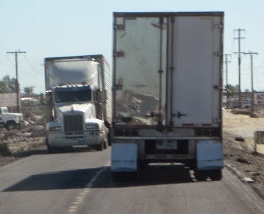 |
| Trucks passing almost seemed impossible (and this was a wider area.) |
So you can see why the back road seemed a welcome change.

 |
| The Pristine Baja Desert |

 |
| OK Gotta say, this sign is a JUST A LITTLE BIT FREAKY! |
And just like that - 2 hours - and 35 miles later
we were back on a brand new paved road.

 |
| Back to the beach along a coastal highway once again. |


We have visited San Felipe on numerous occasions.
However, we had never traveled south and had often heard of Puertocitos.
We were very anxious to see this place.
As we approached the weird little town of randomly spaced trailers and double wides,
Beth commented that to her it looked like "Ajo-by-the-Sea".
Ummm. Yeah. Actually, it kinda does!

Onto San Felipe. For a cruise along the malecon and then a steak dinner.
A comfortable room in a familiar place.
But, sadly our little travel Adventure is over.

We had one more day to our trip, San Felipe to Penasco.
However, our cameras were quiet that day on such familiar roads.
 |
| Additions to the van. |
_________________________________

